

HIGH-ACCURACY ARCHITECTURAL DOCUMENTATION
Long-Range 3D Laser Scanning for Buildings & Architectural Spaces
If you manage buildings, commercial properties, or structural assets, you know that accurate data is essential because every design, renovation, and construction decision depends on precise measurements.
We provide high-accuracy architectural scanning solutions for buildings and structures, capturing detailed 3D reality data of existing conditions with exceptional precision. Our non-destructive survey process captures the complete geometric envelope of your facility, ensuring that every architectural nuance and structural element is perfectly documented. By moving beyond traditional manual surveys, we provide your project teams with a comprehensive digital canvas that bridges the gap between legacy blueprints and modern design requirements.
Verification of existing conditions for renovation & retrofit projects.
Reliable spatial data for facility management & long-term operations.
Precise documentation for regulatory compliance and building permits.
Advanced clash detection and coordination for future design works.
Finalised construction record drawings for project handover and closeout.
Start Scanning Your Project in Canberra
Understanding Architectural Reality Capture
.jpg)
BENEFIT FROM OUR EXPERIENCE
How 3D Laser Scanning Works for Architectural Projects
Using high-precision 3D scanning, we capture complex, high-resolution point clouds with full 360-degree coverage—because every structural element, façade detail, interior feature, and spatial dimension matters. We don’t just capture surfaces; we document your building down to the finest detail, helping you minimize costly errors, streamline planning, and make informed decisions.
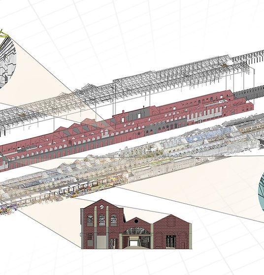
Our engineering team transforms point cloud data into precise 3D models, creating accurate digital representations of buildings and architectural spaces.
We deliver as-built 3D CAD models in Revit, AutoCAD, and other industry-standard formats, ensuring seamless integration into your architectural design and project workflows.
We also provide clear and detailed 2D drawings, including floor plans, elevations, and sections, ensuring accurate documentation for design and planning.

Get Accurate and Up-to-Date CAD Models
Our CAD models are enhanced for performance and usability, ensuring they are not overly heavy or complex, so your system runs smoothly without slowdowns. Elements within the model are organised into layers, giving you full control to include or exclude specific components based on your project needs and budget.
During Construction: To record design changes in real-time.
At Project Handover: For final closeout documentation.
ARCHITECTURAL SURVEYING SPECIALISTS
Applications Of Architectural 3D Laser Scanning
Who Benefits from Architectural Scanning and Documentation?
Architectural Scanning is essential for architects, designers, engineers, and construction professionals who require accurate building measurements and detailed site documentation. Using advanced 3D laser scanning technology, we capture precise real-world data of buildings, structures, and interior spaces to support architectural planning, renovation projects, BIM workflows, and design development while reducing errors, improving project coordination, and enabling informed decision-making throughout the project lifecycle.
Key Uses of Architectural Scanning


Euler Engineering has provided 3D laser scanning services for a wide range of industries.
Agricultural Facilities
Architectural Documentation
Concrete Construction
Historical Documentation & Preservation
Construction
HVAC & MEP Coordination
Clash Detection
Mixed Reality & 3D Projection Mapping
Design Build
Office & Commercial Buildings
Energy & Utilities
Overhead Clearances
Engineering
Oil & Gas Facilities
Real Estate
Power Plants & Process Plants
Telecommunications
Stadiums, Arenas & Theatres
Schools & Universities
Virtual Design and Construction
Accident Reconstruction
Water & Wastewater Treatment Plants
OUR CASE STUDIES
Delivering Precision Across Every Project
