

INDUSTRIAL PLANTS & FACILITIES SCANNING
At Euler Engineering, we provide high-precision 3D laser scanning of industrial plants and facilities using advanced terrestrial LiDAR technology. Our rapid data capture process generates millimeter-accurate as-built models, detailed layouts, and comprehensive reports
INDUSTRIAL PLANTS & FACILITIES SCANNING
Long-Range 3D Laser Scanning for Industrial Plants & Facilities
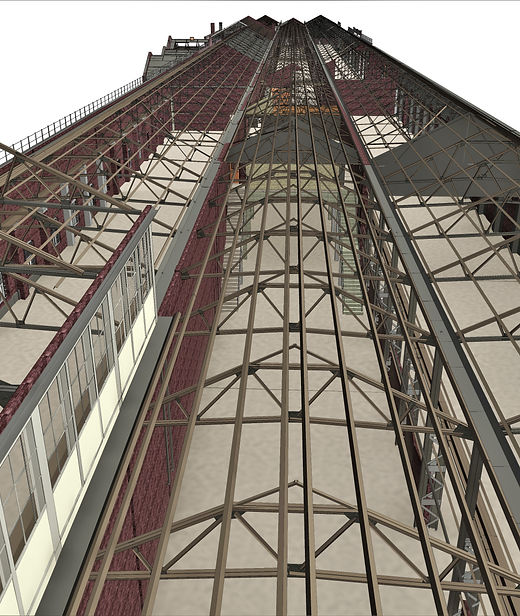
Managing an industrial plant requires absolute precision; when millions are at stake, guessing is never an option. We provide advanced, long-range laser scanning solutions specifically engineered for large-scale environments, including industrial plants, manufacturing facilities, and complex infrastructure.
Because many areas within a facility are not easily or safely accessible, we utilize high-precision, tripod-mounted LiDAR scanners for terrestrial long-range data collection. This allows us to capture accurate, high-definition data from a safe distance without disrupting your operations. Whether you are planning a facility retrofit, developing a digital twin for maintenance, or managing a large-scale expansion, we provide the technical clarity and structural detail you need to move forward with total confidence
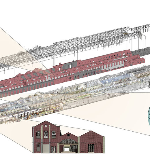
Verification of existing conditions for complex industrial renovation & facility.
Reliable spatial data for long-term facility management, asset tracking, and plant
Precise 3D documentation for regulatory safety compliance and local
High-fidelity construction record drawings to streamline project
Delivered construction record drawings for project handover and closeout.
What Is Industrial Plant & Facility Scanning
Industrial Plant & Facility Scanning
Industrial plant and facility scanning uses advanced 3D laser scanning technology to capture highly accurate digital measurements of industrial environments, equipment, and infrastructure.
Why Industrial Facility Scanning Matters
In complex industrial environments, accurate site data is critical. Our scanning solutions provide precise digital documentation of existing conditions,
Accurate measurements of plant layouts and equipment
Improved planning for upgrades and retrofits
Reduced downtime during maintenance and construction
Better coordination between engineering teams
Enhanced safety and compliance documentation

When Is Industrial Scanning Used?
Industrial scanning can be performed at different project stages to support planning, maintenance, and operational efficiency.
Pre-construction and renovation planning
Facility expansion and retrofit projects
Maintenance and shutdown planning
INDUSTRIAL SURVEYING SPECIALISTS
Applications Of Scanning Complex Facilities
Key Uses of Plants & Facilities Scanning
Who Benefits from Industrial Plants & Faclities Scanning and Documentation?
Industrial Plants & Facilities Scanning is essential for engineers, facility managers, plant operators, and industrial teams who require accurate site measurements and detailed digital documentation. Using advanced 3D laser scanning technology, we capture precise real-world data of industrial environments, equipment, piping systems, and infrastructure to improve project planning, reduce operational errors, support maintenance workflows, and enable informed decision-making across industrial facilities and plant operations.
.jpg)

Euler Engineering has provided as-built scanning services for a wide range of industries.
Agricultural Facilities
Architectural Documentation
Concrete Construction
Historical Documentation & Preservation
Construction
HVAC & MEP Coordination
Clash Detection
Mixed Reality & 3D Projection Mapping
Design Build
Office & Commercial Buildings
Energy & Utilities
Overhead Clearances
Engineering
Oil & Gas Facilities
Real Estate
Power Plants & Process Plants
Telecommunications
Stadiums, Arenas & Theatres
Schools & Universities
Virtual Design and Construction
Accident Reconstruction
Water & Wastewater Treatment Plants
OUR CASE STUDIES
Delivering Precision Across Every Project


